Associate Professor & Head
Department of Geology
Dr. Palpu College of Arts and Science, Pangode, Kerala, INDIA.
Dr. Mathew K. Jacob is an accomplished Geo-scientist and academic specialized in Economic Geology, Geo-resource management, and sustainable development in India. He obtained his Ph.D. in economic geology, from Kerala University, in 1994. for pursuing doctoral research on the Metallogeny of the primary Masters in Applied Geology from Indian Institute of Technology(IIT) Kharagpur, 1982. Bachelor's degree in Geology/Earth Science as first rank holder from Kerala University,1978.
Major research specializations are in the fields of Economic Geology, Structural Geology, and Geo-Chemistry. His doctoral research on the Metallogeny of the primary gold deposits of Nilambur, North Kerala of Southern India as well as research works on the Polachira wetlands of Kerala focussing on geo-resource management is extensive.
Some other areas of research include the metallization of primary gold in the Precambrian greenschist facies rocks of southwest India and Paleogene carbonate deposits of southwest coastal India. Dr. Mathew also focuses on other facets of earth science such as Geomorphology and Petrology. He is actively engaged in research studies related to Environmental Geology & Sustainable development and conservation of water resources.
Dr. Mathew also focuses on other facets of earth science such as Geomorphology and Petrology. He is actively engaged in research studies related to Environmental Geology & Sustainable development and conservation of water resources.
As an academic, Dr. Mathew worked as a Professor and Head of the Department of Geology, Sree Narayana College, Trivandrum in the past. And is currently working as Head of the Department of Geology at Dr. Palpu College of Arts and Science.
Department of Geology
Dr. Palpu College of Arts and Science, Pangode, Kerala, INDIA.
Department of Geology
Sree Narayana Guru College of Advanced Studies, Varkala, Kerala, INDIA.
Post Graduate Department of Geology
Sree Narayana College, Sivagiri, Varkala, Kerala, INDIA.
Department of Geology
Sree Narayana College, Sivagiri, Varkala, Kerala, INDIA.
Doctor of Philosophy in Economic Geology
Department of Geology, University of Kerala, Thiruvananthapuram.
Master of Science in Applied Geology
Department of Geology & Geophysics, Indian Institute of Technology - Kharagpur, West Bengal.
Bachelor of Science in Geology.
Department of Geology, University of Kerala, Thiruvananthapuram.
Specialized in advanced research in geology in areas of economic geology, structural geology geochemistry and geomorphology. Taught geology in the Department of Geology Sree Narayana College, Varkala Thiruvananthapuram District, India.
Did doctoral research on the Metallogeny of the primary gold deposits of Nilambur, North Kerala, Southern India and was awarded Ph.D from the Kerala University
Did research work on the wetlands of Kerala especially the georesourse management of the Polachira wetland area of Kollam district,Kerala state.
Also engaged in the research on the environment of origin of the Quilon limestone, southwest Kerala.
The grey fossiliferous clayey limestone found, and reported at Padappakara eventually became the type area of the Quilon limestone beds. According to the present knowledge the oldest sedimentary formation in Kerala is represented by the Vaikom beds.
In the project, a detailed study of all available published literature related to the Tertiaries of Kerla and in particular Quilon limestone formation was done. An inventory sample of limestone and associated rocks was made during the first four months by way of fiueld work in and around Padappakara, Kanjirode, Thazhuthala, Kottiyam, Kollam, Mayyanad, Kalarkode, Paravoor, Chavara, Karunagapally, Panmana, Alappuzha etc. Geochemical, Micro palaeotological, Macro palaentologcal and ICP studies were conducted.
A preliminary map of the Palaeo-basin is prepared as a part of the project. A location map was prepared indicating places of limestone recovery and exposure both from open wells and from bore wells.
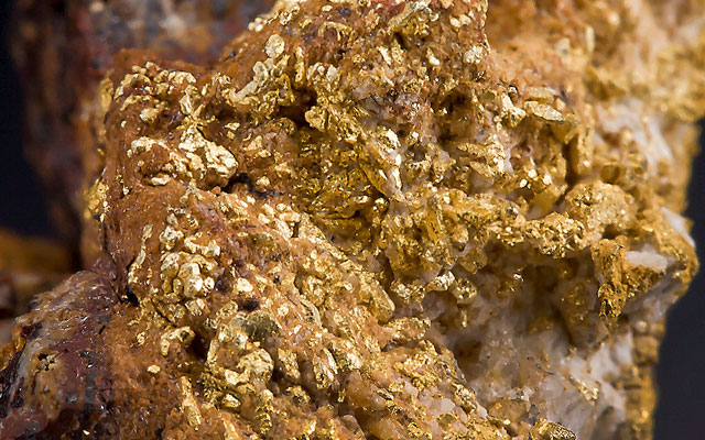
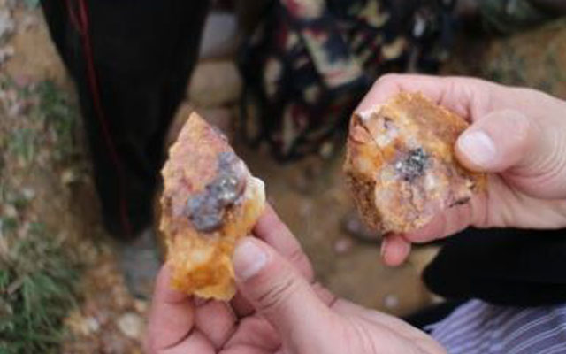
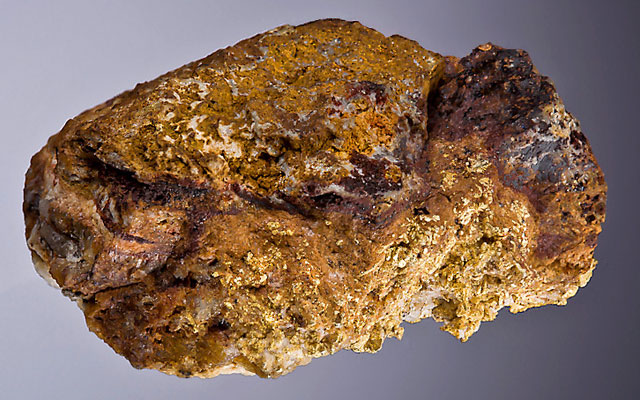
Placer gold grains in the Nilambur Valley of Wynad Gold Field in southern India are characterized by very high purity levels (985–1000). Their Ag-depleted core compositions, enhanced grain size and microscale growth patterns correlate with gold grains associated with laterite profiles in the weathering fronts.
From the morphological and chemical evolution of gold grains associated with primary, supergene and secondary deposits in this region, we identified a two-stage process for the evolution of the highly pure placers, which shows that gold in the primary veins was mobilized, chemically purified, and reconcentrated in the laterite profiles, effecting enhanced purity and grain growth before transfer to the fluvial system.
Further refinement was achieved during fluvial transport, generating natural concentrations of pure gold in the placers.
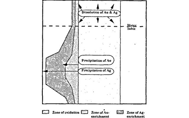
Gold grains from laterite horizons of Nilambur region in northern Kerala exhibit typical morphological characteristics and secondary growth patterns indicative of chemical dissolution, migration and reprecipitation by low temperature fluids attending tropical weathering. Proton-induced X-ray emission (PIXE) analyses of secondary gold grains yielded characteristic spectra for Au, along with Ti and Fe, in the near-absence of Ag and Cu.
This study provides the first direct evidence for the formation of extremely pure gold by natural chemical reconcentration process, principally dictated by the oxidation reactions of iron sulphide minerals associated with the primary mineralization. The results have important bearing on the recently realized economic potential of gold in laterites.
Placer gold grains in the Nilambur Valley of Wynad Gold Field in southern India are characterized by very high purity levels (985-1000). Their Ag-depleted core compositions, enhanced grain size and microscale growth patterns correlate with gold grains associated with laterite profiles in the weathering fronts.
From the morphological and chemical evolution of gold grains as- sociated with primary, supergene and secondary deposits in this region, we identified a two-stage process for the evolution of the highly pure placers, which shows that gold in the primary veins was mobilized, chemically puri- fied, and reconcentrated in the laterite profiles, effecting enhanced purity and grain growth before transfer to the fluvial system. Further refinement was achieved during fluvial transport, generating natural concentrations of pure gold in the placers.
Mechanical translocation of dispersed gold grains from their primary source regions, physical transport in fluvial systems, and accumulation in the form of placers consti- tute one of the potential means of generating economical concentrations of gold. Often fluvial transport of gold grains can enhance their purity by leaching out silver (e.g. Desborough 1970; Grant et al. 1991).
However, the mechanisms that chemically refine gold in the supergene environments prior to their transfer into the fluvial net- work may result in the accumulation of very high purity gold in the placers. Here we report one such example from the Nilambur valley in the Wynad Gold Field of southern India. Our study shows that morphological evo- lution and chemical refinement in the domain of individ- ual grains can provide useful guidelines for identifying the source characteristics of gold.
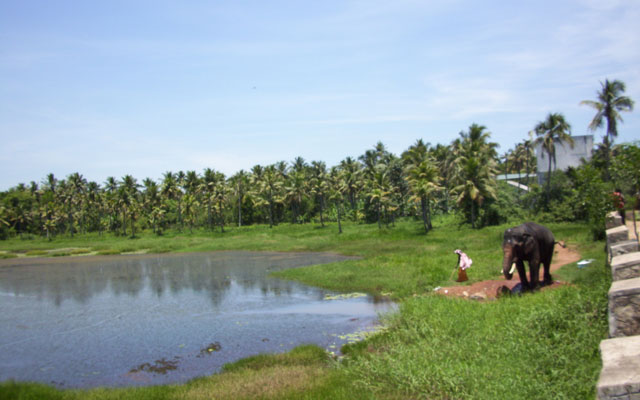
Kerala is to be considered a single spot of tourist attraction which is totally a new concept. The major benefits of geomorphologically integrated tourism in Kerala are uniform development of infrastructure in the state, uniform spreading of the revenue from tourism in the state, participation of greater percentage of population of Kerala in tourism, conservation of ecology and environment and prevention of uncontrolled pollution in the tourists centres.
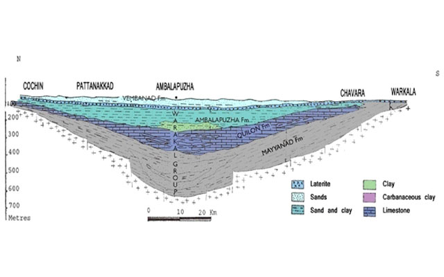
The Neogene succession, located along the southern coastal stretches of Kerala is represented by the sediments belonging to the Vaikom Formation, Quilon Formation, and the Warkalli Formation (Poulose and Narayanaswamy, 1968; Varadarajan and Madhavan Nair, 1978; Raha et al., 1983, Soman, 1997).
These sediments are dated as post Paleocene (Dey, 1962). The Quilon beds bear an important position in Indian stratigraphy as these present evidence of marine transgression along the south-west coast of India during Miocene, similar to the sort of marine deposits along northwestern and western parts of Indian subcontinent (Verma, 1977).
The Vaikom and Warkalli Formations are unfossiliferous, while the Quilon limestone Formation bears rich marine fossils belonging to the Miocene (Burdigallian). The carbonate sediments in the Quilon basin rest unconformably over the Vaikom beds (Nair and Rao,1980).
Forest fires are potential threats to most of the wildlife sanctuaries in the world. Such areas for conservation of precious wildlife in parts of the Western Ghats in India are no exception. The present study area representing the Periyar Tiger Reserve forms a part of the Western Ghats, where during the past decade more than 200 wildfires have been recorded.
Objective: The present study is designed to demarcate the fire risk zones applying principles of geospatial techniques.
Materials and Methods: The technique integrates Remote Sensing and Geographic Information System. Parameters such as land cover type, surface slope, aspect, proximity to settlements, closeness to roads, and elevation have been considered. A Modified Fire Risk Index method has been used for preparing the risk zone map.
Results: The prepared map shows five fire risk zones such as very high, high, moderate, low, and very low. About 27.38% of the study area, according to this study falls within the high and very high risk zones. The final result of the study is validated with the MODIS active fire (hotspot) data, which shows very good reliability. Conclusion: This study based on geospatial technology is very useful to the local authorities for identifying in advance the fire risk zones for prevention and management of forest fires in future.
In recent years, forest fires have become a major disaster in many countries of the world because of their impact on biodiversity, landscape, health, environment, ecology and economy. Forest fires are one of the major natural hazards occurring in the forests of the Western Ghats, a biodiversity hotspot in India. The present study aims to demarcate the risk zones of potential forest fire in Idukki Wildlife Sanctuary using integrated Remote Sensing (RS) and Geographic Information System (GIS) techniques.
Every year, during March-May months, the forests in this area are affected by severe fires. In order to generate the fire risk zone map of the study area, a thematic study was carried out on each of the influencing factors viz. land cover type, slope, distance from settlement, distance from road, and elevation. A Fire Risk Index method was used to prepare the risk zone map. The area of the final map was grouped into five different categories of risk zones, viz. very low, low, moderate, high, and very high.
Finally the risk zone map was validated with the fire incidence data for the last 10 years. Results of this study show that the most important factors which contribute to fire ignition are the human induced factors, also known as the anthropogenic factors. The resulting map of forest fire risk zone can be of great benefit for understanding the fire problem and will offer a more effective database for the preparation and control of forest fires.
In recent years, forest fires have become a major disaster in many countries of the world because of their impact on biodiversity, landscape, health, environment, ecology and economy. Forest fires are one of the major natural hazards occurring in the forests of the Western Ghats, a biodiversity hotspot in India.
The present study aims to demarcate the risk zones of potential forest fire in Idukki Wildlife Sanctuary using integrated Remote Sensing (RS) and Geographic Information System (GIS) techniques. Every year, during March-May months, the forests in this area are affected by severe fires. In order to generate the fire risk zone map of the study area, a thematic study was carried out on each of the influencing factors viz. land cover type, slope, distance from settlement, distance from road, and elevation.
A Fire Risk Index method was used to prepare the risk zone map. The area of the final map was grouped into five different categories of risk zones, viz. very low, low, moderate, high, and very high. Finally the risk zone map was validated with the fire incidence data for the last 10 years.
Results of this study show that the most important factors which contribute to fire ignition are the human induced factors, also known as the anthropogenic factors. The resulting map of forest fire risk zone can be of great benefit for understanding the fire problem and will offer a more effective database for the preparation and control of forest fires.
Wildfires bursting into forests are one of the major natural hazards in the Western Ghats region of Kerala. The aim of the present study is to demarcate the forest and wildfire risk zones in Nemmara Forest Division. This area frequently faces wild land and forest fire.
In this study a combination of Remote Sensing and GIS technology has been used to develop the Fire Risk Index model. The variables used for the present study were fuel type, slope, elevation, road density and settlement density. The selected variables were weighted based on their impact on the fire occurrence. ERDAS Imagine 9.2 and ArcGIS 9.3 software tools were used to prepare fire risk zone map.
The prepared forest fire risk map of Nemmara Forest Division has classified the area into five risk zones: very high, high, moderate, low and very low. To validate the prepared map, the result was compared with forest fire inventory points.
Forest fires are of common occurrence in parts of Wayanad Wildlife Sanctuary in the central western slopes of Western Ghats, especially during the months from February to April. They pose great threat to forest vegetation, animal life and scattered human settlements. The present study aims to demarcate forest fire risk zones in Wayanad Wildlife Sanctuary in Kerala state using Remote Sensing (RS) and Geographic Information System (GIS) techniques.
This study considers human related factors as well as environmental factors. The factors selected for the study are land use/land cover, distance from settlement, distance from road, slope, and elevation. The thematic maps are prepared using ArcGIS 9.3 and ERDAS Imagine 9.2 software tools. A Fire Risk Index model is used to prepare the forest fire risk zone map. In the prepared map, the area has been classified into three categories viz., high, moderate, and low risk zones. Analyses of the primary data related to previous incidences of forest fires in this area have validated the reliability of the application of this methodology.
The GIS based forest fire risk prone area zonation therefore appears to be valid. Thus the present methodology can be used effectively in mitigation of forest fires, rehabilitation and restoration programs.
In recent years, forest fires have become a major disaster in many countries of the world because of their impact on biodiversity, landscape, health, environment, ecology and economy. Forest fires are one of the major natural hazards occurring in the forests of the Western Ghats, a biodiversity hotspot in India.
The present study aims to demarcate the risk zones of potential forest fire in Idukki Wildlife Sanctuary using integrated Remote Sensing (RS) and Geographic Information System (GIS) techniques. Every year, during March-May months, the forests in this area are affected by severe fires. In order to generate the fire risk zone map of the study area, a thematic study was carried out on each of the influencing factors viz. land cover type, slope, distance from settlement, distance from road, and elevation. A Fire Risk Index method was used to prepare the risk zone map. The area of the final map was grouped into five different categories of risk zones, viz. very low, low, moderate, high, and very high.
Finally the risk zone map was validated with the fire incidence data for the last 10 years. Results of this study show that the most important factors which contribute to fire ignition are the human induced factors, also known as the anthropogenic factors. The resulting map of forest fire risk zone can be of great benefit for understanding the fire problem and will offer a more effective database for the preparation and control of forest fires.
Forest fires represent one of the major natural disasters that are common in the tropical forests of India. The forests in Thenmala forest division are also prone to fires. The objective of this study is to demarcate the fire risk zones in Thenmala forest division using geospatial tools.
A Fire Risk Index model has been developed considering the land cover type, terrain geomorphology (slope and elevation), and anthropogenic factors (distance from settlement and distance from road). The area of the prepared forest fire risk zone map is classified into five risk zones viz. very low, low, moderate, high, and very high. The high and very high risk zones jointly constitute 51.57% area of the forest division. Most of the forest fires in this region have an anthropogenic origin.
The result of this study is validated by the fire incidence points for the years from 2004 to 2015. It shows very good reliability. This confirms the efficacy of the present methodology and can be used in any terrain of similar conditions. The prepared forest fire risk zone map is a valuable data for planners and decision makers for effective resource management and protection
Forest fires are the most common natural disturbance occurring in the Western Ghats, especially during the summer season. The present study area is also prone to forest fires.
In this study, an attempt has been made to locate and map the potential fire risk zones in the Periyar Tiger Reserve using geospatial techniques. The factors selected in this study are land cover type, slope, distance from settlement, distance from road, and elevation. The forest fire risk zone map is generated using the developed Fire Risk Index model. In the prepared map, the area has been classified into five risk zones viz. very low, low, moderate, high, and very high.
The result has been validated with the fire incidence points for the past 10 years. The risk zone map of the Periyar Tiger Reserve is to be helpful for natural resource managers or planners in the management and environmental protection of resources.
Tsunamis are caused by the displacement of a large volume of water, generally in an ocean or a sea. Submarine earthquakes, volcanic eruptions, underwater explosions, continental shelf landslides, glacier calvings, meteorite impacts, and other powerful submarine disturbances have the potential to generate a tsunami. Tsunami vulnerability zonation and mapping is very important to mitigate the impact due to tsunami disaster. The coastal areas of Kollam district, the present study area were seriously affected by the catastrophic Indian Ocean tsunami of December 26, 2004.
This study aims to demarcate tsunami vulnerable areas in Kollam district using Remote Sensing and GIS techniques. A multi criteria decision analysis has been carried out using five parameters, namely land use/land cover, slope, elevation, geomorphology, and distance from shoreline and based on thematic maps prepared with respect to them. The prepared vulnerability map area was classified into five zones: safe, rather safe, moderate, rather vulnerable, and vulnerable. The village boundary was overlaid on the vulnerability map in order to identify and highlight the vulnerable villages.
This study provides an interactive method to identify tsunami affected areas after a disaster in addition to mapping tsunami vulnerable areas before a disaster, in an effort to help manage future disasters.
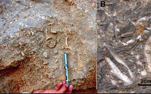
The Neogene succession, located along the southern coastal stretches of Kerala is represented by the sediments belonging to the Vaikom Formation, Quilon Formation, and the Warkalli Formation (Poulose and Narayanaswamy, 1968; Varadarajan and Madhavan Nair, 1978; Raha et al., 1983, Soman, 1997). These sediments apparently rest unconformably over the Archaean metamorphosed crystalline basement. While the older Vaikom and the younger Warkalli beds are unfossilliferous the Quilon limestone beds, sandwiched between them, are rich in marine macrofossils.
The present paper incorporates a systematic account of the macro invertebrate fossils recovered from the limestone beds that show dominance of Gastropoda followed by Bivalvia 26 (pelecypoda). The biostratigraphic correlation and palaeo-environmental conditions for the growth of these fauna have also been discussed.
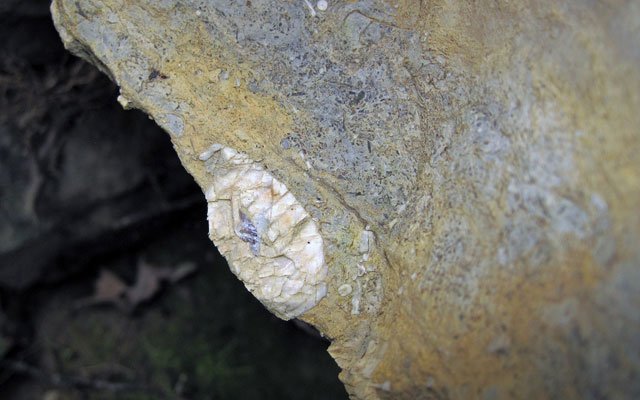
The kaolin deposits at Melthonnakkal and Pallipuram mines form part of the Warkalli Formation belonging to the Tertiary sequence in southern Kerala and occur at the boundary between the Tertiary sequence and Precambrian granulite facies metapelites (khondalites). The sedimentary clays are composed mainly of kaolinite, quartz and gibbsite. XRD and SEM studies have revealed that kaolinite is well-crystallized variety and the platy crystals are scarcely broken in the sedimentary clays.
These sedimentary kaolins are considered to have been formed by intense tropical weathering of the khondalites, and subsequently transported and deposited with high organic input into lakes near the weathering crust over the basement rock. Besides, the surficial parts of the sedimentary deposits are extensively lateritized with the formation of goethite and hematite by Quaternary tropical weathering processes.
Placer gold grains in the Nilambur Valley of Wynad Gold Field in southern India are characterized by very high purity levels (985–1000). Their Ag-depleted core compositions, enhanced grain size and microscale growth patterns correlate with gold grains associated with laterite profiles in the weathering fronts.
From the morphological and chemical evolution of gold grains associated with primary, supergene and secondary deposits in this region, we identified a two-stage process for the evolution of the highly pure placers, which shows that gold in the primary veins was mobilized, chemically purified, and reconcentrated in the laterite profiles, effecting enhanced purity and grain growth before transfer to the fluvial system. Further refinement was achieved during fluvial transport, generating natural concentrations of pure gold in the placers.
Gold grains from laterite horizons of Nilambur region in northern Kerala exhibit typical morphological characteristics and secondary growth patterns indicative of chemical dissolution, migration and reprecipitation by low temperature fluids attending tropical weathering. Proton-induced X-ray emission (PIXE) analyses of secondary gold grains yielded characteristic spectra for Au, along with Ti and Fe, in the near-absence of Ag and Cu.
This study provides the first direct evidence for the formation of extremely pure gold by natural chemical reconcentration process, principally dictated by the oxidation reactions of iron sulphide minerals associated with the primary mineralization. The results have important bearing on the recently realized economic potential of gold in laterites.
Forest fire is a common problem in the Western Ghats regions of Kerala. Therefore forest fire risk analysis is necessary for forest management. The present study area is also prone to forest fires. The present study deals with the identification of fire risk zones in Peppara Wildlife Sanctuary, Western Ghats mountain region, Kerala using GIS and Remote Sensing techniques. The forest fires are caused due to environmental and human related factors. This study considered 5 factors namely, land use/land cover, slope, elevation, distance from road, and distance from human settlements. Relevant thematic layer maps representing these factors that are related to forest fire occurrence have been prepared by using Geographic Information System (GIS) and Remote Sensing (RS) software tools.A multi parametric weighted index model was used to prepare the fire risk zone map using ArcGIS and ERDAS Imagine software tools. The forest fire risk zones were segmented into four, viz., low, moderate, high and very high risk zones. Forest fire risk maps are useful tools for the efficient planning and management of forest in the Western Ghats mountain region.
District Environmental Advisory Committee (DEAC), Kollam district, Government of Kerala.
Formulate Projects for Watershed Development (NWBRA), Government of Kerala.
Peoples Campaign Program for Sports and Literacy, Kollam district, Government of Kerala.
Biodiversity Conservation of Kollam district, Government of Kerala.
Geological Society of India.(FGS)
Geological Society of Kerala
Geological Society of Kerala
Indian Society of Remote Sensing
Indian Red Cross Society (IRCS), New Delhi, India.
TRACK - Trauma and Accident Care, Kollam.
International Association for Promoting Geoethics (IAPG), Rome, Italy.
The Association of Geoscientists for Interandational Development (AGID).
Department of Geology and Geophysics, Indian Institute of Technology – Kharagpur, West Bengal, India.
Kollam District Tennis Association, Kerala
Kollam District Chess Association, Kerala
Kollam District Soft Ball Association, Kerala
International Red Cross Society
Malayalee Magicians Association
Numismatic and Philatellic Association, Kollam
Fine Arts Society, Kollam
Post Graduate Department of Geology, Sree Narayana College, Varkala, Kerala
Post Graduate Board of Studies in Geology, University of Kerala
Department of Geology, Sree Narayana College of Advanced Studies, Varkala, Kerala
Post Graduate Department of Geology, Dr Palpu College of Arts and Science, Pangode, Puthussery
Reviewed a paper titled "Spatial-temporal dynamics of NDVI and its response to climate factors" for "The 3rd International Conference on Water Resource and Environment (WRE 2017)" to be held in Qingdao, China; during 26th - 29th June.
Reviewed a paper titled "Flood Severity Index in Klang Valley, Malaysia" for "The 3rd International Conference on Water Resource and Environment (WRE 2017)" to be held in Qingdao, China; during 26th - 29th June.
Reviewed a paper titled "Characteristics of Rainfall in Peninsular Malasia" for "The 3rd International Conference on Water Resource and Environment (WRE 2017)" to be held in Qingdao, China; during 26th - 29th June.
Reviewed a paper titled "Evaluation of Water Resources System Vulnerability Based on Co-ope ative Co-evolutionary Genetic Algorithm and Projection Pursuit Model under the DPSIR Framework" for "The 3rd International Conference on Water Resource and Environment (WRE 2017)" to be held in Qingdao, China; during 26th - 29th June.
Reviewed a paper titled "The Numerical simulation of underground water and the immers on area prediction of downstream area in right auxiliary dam of Shifosi reservoir" for "The 3rd International Conference on Water Resource and Environment (WRE 2017)" to be held in Qingdao, China; during 26th - 29th June.
Engaged in studies related to Geo Resource Management, Conservation of water resources, Economic Geology, Environmental Geology and Geo Ethics
Agriculture, Horticulture, Travel, Music, Photography, Film and Drama, Sports
Community Education, Rational Thinking, Youth activities, Relief Work, Disaster Management, Editing & Publishing, Motivational Talks Resouce Person
Could impart theortical, practical, professional and ethical training to students over the last four decades.
Could give comprehensive personal development training to a large number of students in the capacity of patron of Malayala Manorama Balajana Sakhyam, Kollam district.
Proposed holistic action plan for the development of Polachira wetlands, Kollam district.
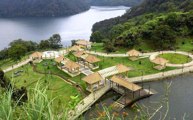
Studied and proposed action plan for the developemnt of geo tourism of Ayathil stream, Kollam district.
Prepared Geo Reoresource Management Maps of Chathannoor and other Panchayats.
Organized and initiated the Geological Society of Kerala
Extended Relief work at locations affected by the 2018 floods.
Initiated and developed a public library in the local village.
I would be happy to have a chat or be of research assistance or support for yourself and your team.